You are here
Increase Pollinator-Friendly Areas (Ongoing)
Recent Project Updates
-
2/4/2026This month, the Land and Water iCAP Team met on Teams on February 4th, 2026, at 9:00 AM for the team's monthly meeting. In the meeting, the team discussed future goals and potential projects for students to work on throughout the semester. Some of...
-
3/7/2025The Land and Water team met on March 7th, 2025, at 9 am on Teams this month. In this week's meeting, the team discussed prairie strips, sustainable water usage on campus, milkweed plantings for pollinators, and activities to participate in this...
Project Family
-
Responsible Stewardship of Campus Land and Water
-
Increase Pollinator-Friendly Areas
- Burrill/ Morrill Walkway
- Campus Honors House
- Chi Omega native plants
- Davenport Hall Carbon Garden
- LAR Native Plants
- Low Mow Zones
- Meadow at Orchard Downs
- Native Plants at Arboretum
- Orchard Downs Multifunctional Landscape (ODMFL) [ARCHIVED]
- Plantings at Dorner Drive Retention Pond
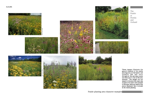
- Prairie Restoration at Florida & Orchard
- Small Prairie at Natural Resources Building
- The Illinois Path [ARCHIVED]
- Uni High Butterfly Garden
- Vet Med Prairies
- Woodland Plants at NRB
- Obtain and Publicize Water Data
- Rainwater Management
- Reduce Potable Water Usage
- Root to Roof Program
- Sustainable Agricultural Practices
- Sustainable Landscapes Plan
- Tree Campus Higher Education
- Use of Non-Potable Water (such as Greywater)
- Water Conservation [ARCHIVED]
-
Increase Pollinator-Friendly Areas
Key Objective
-
4.2.2 Increase Pollinator-Friendly Areas
(iCAP 2020)
Associated Collections
Description
Pollinator-Friendly Areas
Themes
-
Primary Theme:
Other Themes:
Project Location(s)
This map is interactive! Click (or touch) and drag to pan; scroll (or pinch) to zoom.

